338
Cartografia Napoleonica
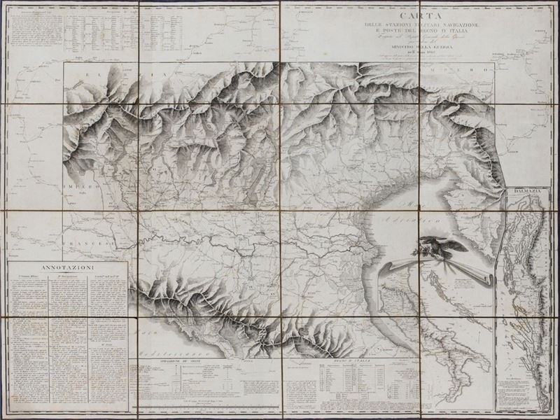
Map of the military stations, navigation and post offices of the Kingdom of Italy carried out in the General War Depot by order of the Ministry of War in the year 1808. With the addition of the Post Offices and Military Stations leading to the Neighboring States, 1808
Estimate
€ 200 - 300
Sold
€ 640
The price includes buyer's premium
Do you have a similar item you would like to sell?
Information
sl, se, 1808. ( mm. 960 x 1300). Copper engraved paper, composed of 16 panels glued on canvas, case original in marbled hardcover, slight defects.
Specialist Notes
Rare map published during the Napoleonic wars, depicts northern Italy between Domodossola, Vipiteno, Istria to the north; Lucca and Pesaro to the south, Piedmont is barely mentioned. Shows the orography with hatching and indicates the state capitals, provincial and district capitals, municipalities, etc., fortified squares, postal roads and major roads, second-order roads, rivers and canals and their navigability , distance in hours of walking, miles of navigation on bridges and waterways, etc. The map is completed, out of picture, by the purely demonstrative representation of the road network. Bottom to & nbsp; right a general map of Italy and Dalmatia. & nbsp;
Contact
Suggested lots
Caricamento lotti suggeriti...