339
Cartografia
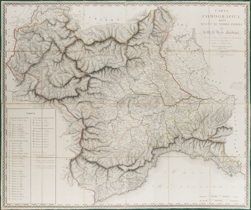
Chorographic Map of the States of Firm Land of S. M. Il Re di Sardegna Divided into Provinces and Cantons of Mandamenti according to the recent fixation made with Regi Editti, 1819
Estimate
€ 150 - 200
Sold
€ 384
The price includes buyer's premium
Do you have a similar item you would like to sell?
Information
Turin, Gaetano Balbino, 1819. (1120 x 1380 mm). Wall paper mounted on canvas, consisting of 20 joined squares, on the left a large box with the" Index "with the subdivision of the provinces according to the Senate to which they belong, colored borders, coeval hardcover case, large carataceous piece with manuscript title and date.
Specialist Notes
Rare wall map, one of the first of the period of the Restoration started in 1814 with the return of King Vittorio Emanuele I, with the description of the Savoy states including Savoy, Piedmont and Liguria. , despite the influence of Napoleonic cartography, introduces some innovations including the addition of existing irrigation canals and canals and those planned, obtained from a hydrographic map compiled by the Director of the R. Canali Cav. Ignazio Michelotti. Aliprandi, The great Alps in cartography 1482-1885 , p. 251-252.
Contact
Suggested lots
Caricamento lotti suggeriti...