Information
190 x 108
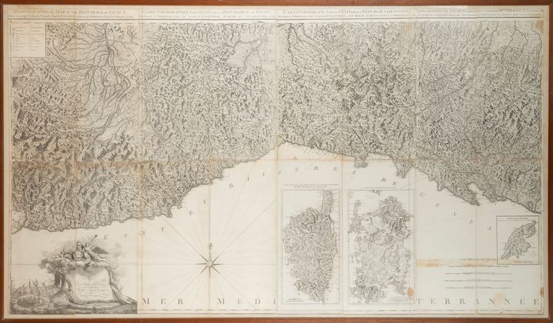
Original antique topographic map from 1784, in eight sheets applied on canvas in detached sections, depicting the territory of the States of the Republic of Genoa. The reference model, the Carta de la Riviera de Genova by Chafrion, is already declared in the title where it is specified that compared to this one it presents "many increases and corrections". The title is reported at the top extra-margin in English, French, Italian and German.
In the upper left corner, within a simple box, are the conventional signs indicating: Fortified city, City with a wall, Village, Established Post Office, etc. In the lower right corner, in the body of the map, are the graphic scales. Next to the scales is the representation of the Island of Caprara at the scale of half a mile or 3000 Genoese Palms and the relative indication of the degrees of longitude and latitude. Also next to the graphic scales are the representations of the islands of Corsica and Sardinia, each in its own box with graduated margin and extra-margin title Carte de l'Isle de Corse Tireé sur les lieux par ordre de Mr le Marechal de Maillebois and Carte de l'Isle de Sardaigne .
In the lower left corner, within a decorative cartouche behind which can be seen a depiction of the port of the city of Genoa, the dedication to "Citizen Michel Angelo Cambiaso" is reported.
Paper mounted on canvas, slight losses on the external margins.
Contact
Condition report
To request a Condition Report, please contact libriestampe@finarte.it
The department will provide you with a general report of the condition of the property described above. Please note that what Finarte declares with respect to the state of conservation of the objects corresponds only to a qualified opinion and that we are not professional conservators or restorers.
We urge you to consult with a restorer or conservator of your choice who will be better able to provide a detailed, professional report. We always suggest prospective buyers to inspect each lot to satisfy themselves as to condition during the exhibition days as indicated in the catalog.
Suggested lots
Caricamento lotti suggeriti...
More Lots

148
Facade of the Church of S. Maria di Carignano in the City of Genoa, 1790
Estimate € 80 - 100
Starting bid € 80
