Estimate
€ 1.000 - 2.000
Sold
€ 1.290
The price includes buyer's premium
Do you have a similar item you would like to sell?
Information
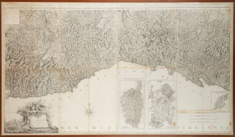
190 x 108
Original antique topographic map from 1784, in eight sheets mounted on canvas in separate sheets, depicting the territory of the States of the Republic of Genoa. The reference model, Chafrion's Carta de la Riviera de Genova , is stated in the title, which specifies that compared to the latter, it presents "many augmentations and corrections." The title appears at the top, outside the margin, in English, French, Italian, and German.
In the upper left corner, within a simple box, are the conventional symbols indicating: fortified city, city with a wall, village, established post office, etc. In the lower right corner, in the body of the map, are the graphic scales. Next to the scales is a depiction of the island of Caprara at a scale of half a mile or 3000 Genoese palms, along with the corresponding degrees of longitude and latitude. Also next to the graphic scales are depictions of the islands of Corsica and Sardinia, each in its own box with a graduated margin and an extra-margin title : Carte de l'Isle de Corse Tireé sur les lieux par ordre de Mr le Marechal de Maillebois and Carte de l'Isle de Sardaigne .
In the lower left corner, within a decorative cartouche behind which can be seen a depiction of the port of the city of Genoa, is the dedication to "Citizen Michel Angelo Cambiaso".
Paper mounted on canvas, slight losses on the external margins.
Contact
Suggested lots
Caricamento lotti suggeriti...