Estimate
€ 300 - 500
Sold
€ 381
The price includes buyer's premium
Do you have a similar item you would like to sell?
Information
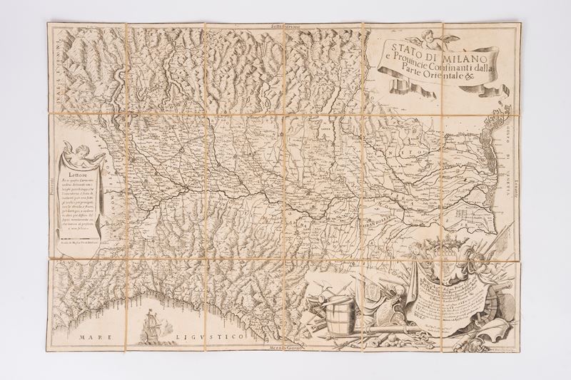
Etching and engraving, 426 x 614 mm. Title within a ribbon held up by a winged cherub at the top right. Halfway up, near the left margin, a drape is held up by another winged cherub with the inscription: “Reader / If on this map / you do not see all the / small places outlined, know that / the intention has been / to place for now / the most important ones before your eyes, / with the Roads, and Rivers, / to then give you a glimpse / in another, more detailed / drawing that (sic), / which is missing at present, / and is happy to see” followed by the “Scale of Twenty Italian Miles”. In the lower right corner stands an elaborate Baroque-style cartouche, decorated with various types of coats of arms, which frames a drape held up by two putti bearing the dedication inscription: “To Your Most Illustrious and Excellency, Prince Col. Mo / Mr. Pirro Visconte Borromeo Arese, Count of the / Pieue di Trebbia of the Secret Council of His Majesty / and his General Commissioner of the Army of the State / of Milan, Lombardy, Piedmont &c. / During the time that I am serving in Your Excellency's office, I have had the opportunity, / on the occasion of the Commissions granted to me by Your Excellency, to carefully recognize / the Provinces, Places, Sites, and Rivers with their Borders of this / State. They are to be outlined in this Map, which I present, or rather return to / Your Excellency as yours. I hope to meet with generous approval, and / I bow deeply. Milan, August 28 1703. / Of Your Excellency / Your Most Humble God, and most obligatory Servant / Giulio Carlo Frattino”. Above the banner stands the Visconti coat of arms with the “biscione”, symbol of Milan, surmounted by a county crown.
The paper is covered in canvas and enclosed in an elegant contemporary case.
The paper is covered in canvas and enclosed in an elegant contemporary case.
Specialist Notes
The map shows all of Lombardy, Veneto, and Liguria, as well as parts of Emilia Romagna as far as Bologna and Tuscany as far as Massa. The geographical representation is very summary and inelegant compared to other contemporary maps, but it is, however , much more accurate and effective . The map was undoubtedly published as a single sheet; in fact, in one of the cartouches, the author announces the release of a later, more detailed map, of which, however, no record is available. No certain information exists about the author, other than the fact that the year following the publication of this map, in 1704, Frattino published a map of the territories bordering the State of Milan to the west. As he himself states in the dedication, he had the opportunity to travel throughout the territory depicted on the map while carrying out the duties entrusted to him by the dedicatee, Pirro Visconti. Borromeo, General Commissioner of the Army. From this we deduce that Frattino was likely a military official charged with gathering firsthand information on a wide variety of territories.
Suggested lots
Caricamento lotti suggeriti...
![The present state of all countries and peoples of the natural, political, and moral world [...]. Volume XIX [...] or a description of the Milanese, Parmaese, Modenese, Mantuan, and Venetian Lombardy](https://api.finarte.it/api/lotto/immagine/189853/0/300.jpg)